Central Meteorological Observatory: The rainfall in the south enters the strongest period, and the strong cold air affects China from west to east.
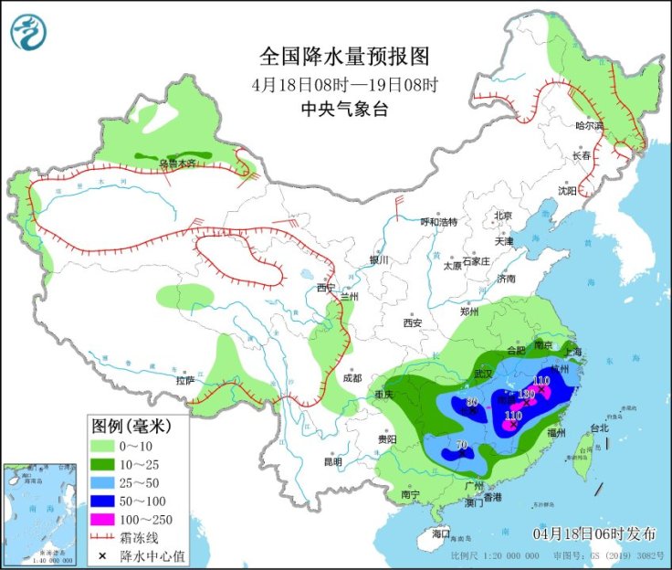
Cctv newsAccording to the website of the Central Meteorological Observatory, the rain in Sichuan Basin, Hunan, Jiangxi, Fujian and other places increased significantly yesterday (17th) at night. Field monitoring shows that in the past 24 hours, heavy rain or rainstorm occurred in parts of central Sichuan Basin, southwestern Chongqing, northeastern Guizhou, central Hubei, northeastern Hunan, northwestern Jiangxi, southeastern Fujian and eastern Guangdong, and local rainfall in Chongqing Jiulongpo and Beibei exceeded 100 mm; The above-mentioned areas are accompanied by a wide range of lightning activities, with thunderstorms and strong winds of magnitude 8 or above in the local area and hail in the northwest of Guizhou.
The Central Meteorological Observatory issued a blue rainstorm warning on the morning of the 18th: It is expected that this round of heavy rainfall in southern China will enter the strongest period from day to night, with heavy rains in parts of Hunan, Jiangxi, Anhui, Zhejiang, Fujian, Guangxi and Guangdong, and heavy rains (100-130 mm) in eastern Jiangxi, southwestern Zhejiang and northwestern Fujian. Some of the above areas are accompanied by short-term heavy rainfall (the maximum hourly rainfall is 20 ~ 50 mm, and the local area can exceed 60 mm), local thunderstorms and strong winds and other strong convective weather.
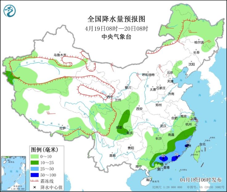
Tomorrow, the heavy rainfall area will be pushed south to Fujian and Guangdong, and there will be heavy rain in southern Fujian and central Guangdong. Meteorologists reminded that in the coming week, there will be rainy weather in most parts of the south, and strong convection will occur frequently, and there will be a moderate to heavy rain on the 20 th to 23 rd. It is suggested that the public should pay close attention to the imminent forecast and early warning information released by the local meteorological department in time, do not go to high-risk areas such as mountainous areas during the concentrated rainfall period, and avoid going out during the active period of strong convection. Jiangxi, Zhejiang, Fujian and other places have high rainfall intensity and accumulated rainfall, so it is necessary to be alert to urban and rural waterlogging, flash floods and geological disasters that may be caused by local heavy rainfall.
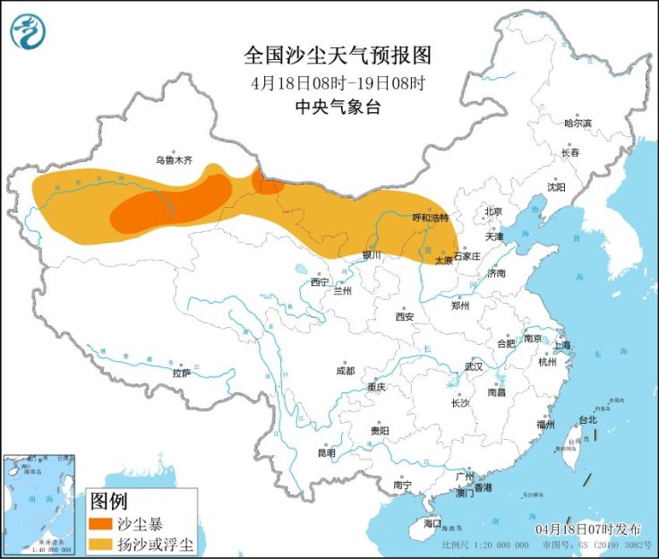
In addition, from 18th to 21st, a strong cold air will affect most parts of China from west to east. During the period, there were 4 ~ 6 winds in most parts of northwest China, North China, Northeast China, Huanghuai, Jianghan, Jianghuai and other places, with gusts of 7 ~ 9, and gusts in Shankou area of Xinjiang could reach 12; The average daily temperature in the above areas has dropped by 6 ~ 10℃ successively, and the temperature has dropped by 12 ~ 14℃ in some areas and above 16℃ locally. In addition to the windy and cool weather, in the next three days, there will be sand or dusty weather in eastern and southern Xinjiang, Qaidam Basin in Qinghai, Gansu, central and western Inner Mongolia, Ningxia, north-central Shaanxi, northern North China and western Northeast China, and sandstorms in eastern and southern Xinjiang and parts of western Inner Mongolia.
The public in the above-mentioned areas should pay close attention to the temperature change, adjust their clothes in time, prevent the adverse effects of strong winds and dust on traffic and travel, and pay attention to the health risks of air pollution caused by dust weather on the human respiratory system.